My career has afforded me the opportunity to be part of what I believe to be a wonderful and generous community; the world geospatial community. A typically happy group of geo-nerds armed with laptops, gps enabled gadgets, and a strong foundation of thinking spatially.
Now, this community certainly has some big business motives behind it, but whenever there is a disaster, or crisis like we are seeing now in Haiti, this community comes together and throws everything it has to offer to help. It energizes me to do what I can to help in these times of need and dedicate myself to applying my trade to the cause. And as a Google employee, I'm blessed to have the full support of my management to work full time when necessary on these events.
While the first few hours of this particular disaster were frustrating as I watched the machine slowly gear up, I am blown away at the response we've pulled together - we're actually learning from these events and each one seems to get a little easier to manage - even if the scale of the disasters always seems to increase.
I sat on an early conference call with representatives of all the major GIS vendors, first responders, geo-nerds, NGOs, govies, and the media where everyone brought what they could do to the table and people teamed up to go do what they do best together.
For example, I watched Google, DigitalGlobe, and GeoEye all work together to get
stunning imagery collected, processed, and published FREE to the international community to help a wide array of aid workers and first responders within 24 hours.
I watched the National Geospatial Intelligence Agency, the US State Department, and other government agencies get critical and informative data and
applications out the door and into the hands of people that needed them within mere hours of the disaster - a far improvement from the Katrina days!
Perhaps most impressive has been the response
that Mikel blogged about to the utter lack of vector data that the Geo Community had access to just after the earthquake.
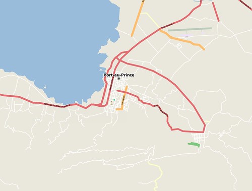
Stealing his images, just look at the difference in
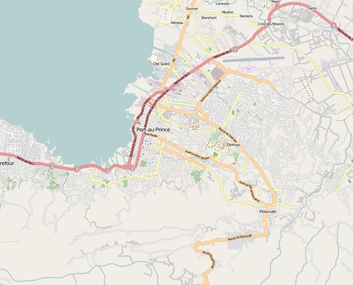
OpenStreetMap Port-au-Prince in just a few days of the Geo Community swarming and finding old CIA library maps, public domain maps, etc and the new imagery released by the commercial satellite providers.
OSM just after the Earthquake
OSM Today
Now, that transformation is wonderful - it is astounding - but it isn't complete because there is a Split in the Geo Community that isn't being well addressed.
OpenStreetMap is not the only community data collection platform - Google also has
MapMaker which has similar tools and goals, and has done a very great job of expanding Google Maps to areas of the world where data was not traditionally available. If I lived in an area that previously had blank Google Maps coverage, I was given the tools to fix that problem and many users around the world have been happy to work on maps of their own area so they can enjoy Google Maps, Directions, etc.
I thought it was great that in addition to the countries from which Google already allows non-profits to download MapMaker data, that Google added the data from Haiti and is now allowing any non-profit to download and use Google's data to help during this crisis.
But OSM and MapMaker aren't talking and I think it is a big problem - if you want to help rescue efforts in Haiti where do you go to digitize? OSM? MapMaker?
How can 2 projects be expected to be in synch? Which is more "correct"? Which is more current?
This split means that these questions have to be asked by first responders, and by those working to create products for them.
"Is that road up there passable?" "Does it really exist?"
It means that the Geo Community is responsible for an extra decision between a first responder and a VICTIM.
As it stands right now, even though the MapMaker data is free for non-profit use, projects like OSM can't use the data because there are commercial uses for OSM and the data belongs to Google, not OSM.
These are the old fights of GIS data; these are Navteq and TeleAtlas bugaboos IMHO, not what I expect to see today!
The differences are pretty glaring between OSM and MapMaker in some cases - take a look at the data I downloaded from both over Port-au-Prince.
The data is similar, but different, and needs to be conflated. Where that conflation happens, how it happens, I don't know - but I do know that we need to do something to fix this split before it gets people hurt.
That said, it is good to have 2 or more different projects; it forces competition in the tools, each project has different goals and metrics of success, and it probably ultimately means more community contribution as different groups migrate to different platforms - all adding to the cumulative Geo Community base data.
However, the data ultimately has to be conflated somewhere - and I urge OSM and MapMaker to work more closely with each other and build some sort of cross platform utility that lets users share edits and co-create data.